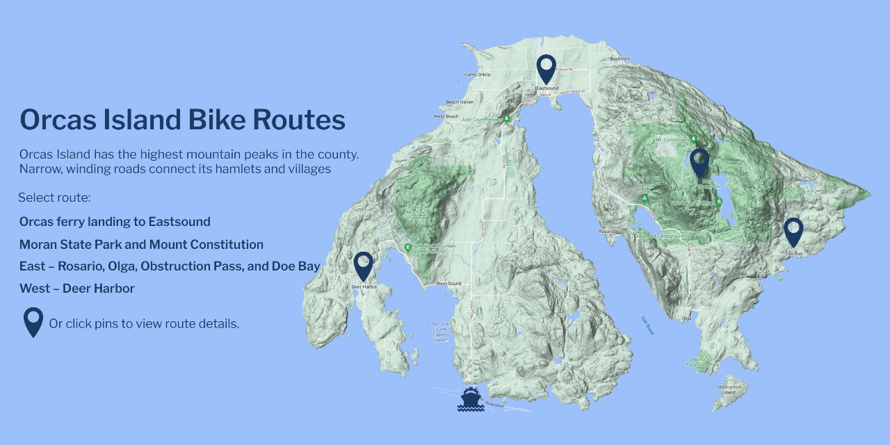
Orcas Island Bike Routes
Orcas Island has the highest mountain peaks in the county. Narrow, winding roads connect its hamlets and villages
Or click pins to view route details.
Select route:
West – Deer Harbor
East – Rosario, Olga, Obstruction Pass, and Doe Bay
Moran State Park and Mount Constitution
Orcas ferry landing to Eastsound

Orcas ferry landing to Eastsound
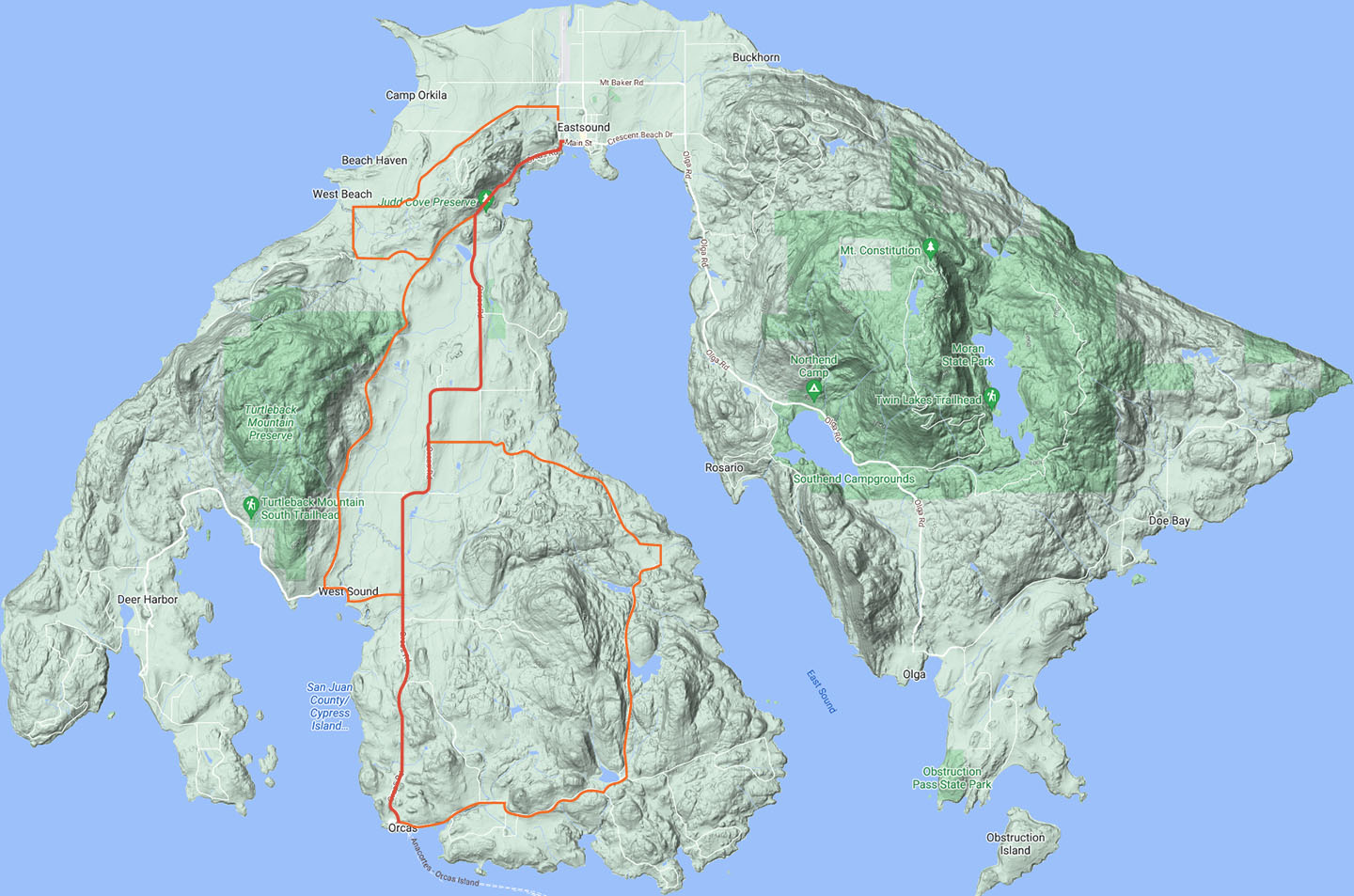
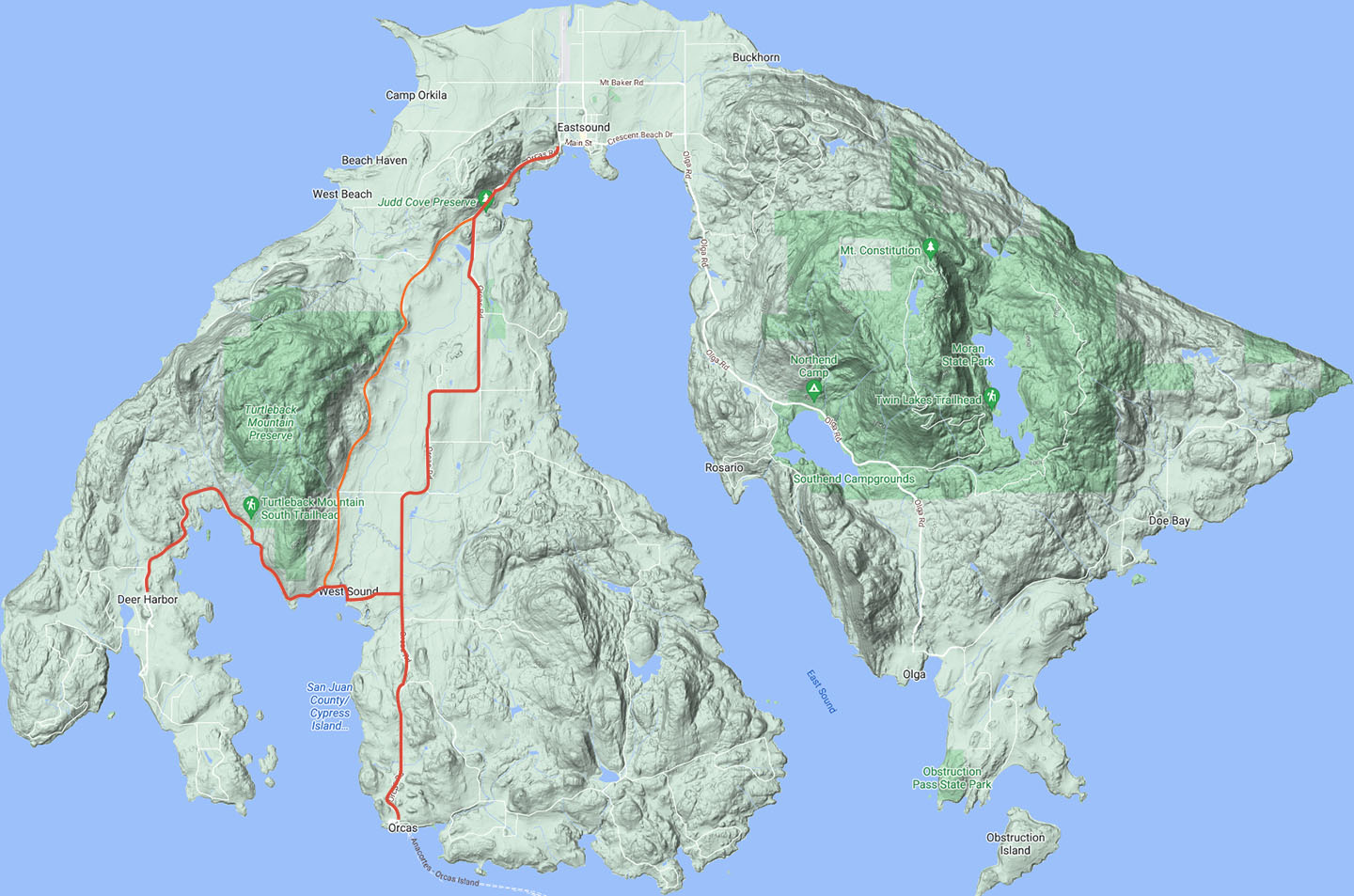
The arrival of the ferry on Orcas means one important thing to cyclists: traffic. A large ferry might disgorge 100 or more cars, and most of them end up on the Horseshoe Highway route into Eastsound (8). It’s a good idea to save your lungs and your sanity by waiting until the crowd has dispersed.
Although Horseshoe Highway is the shortest and flattest route into town, the volume and speed of the traffic can be intimidating. You can largely avoid this problem, and choose a more scenic route in the bargain, by taking Crow Valley Road (4). To get there, follow Horseshoe Highway 1.5 miles to the West Sound turn, where you take a left. A half-mile downhill run takes you to West Sound, where you’ll reach an intersection with a nice view of a harbor on your left. Take a right onto Crow Valley Road and follow it for 4.75 miles. You’ll come to a stop sign with a hardware store on your left.
At this point, you can go straight ahead and rejoin Horseshoe Highway for a mostly downhill run to Eastsound, or you can turn left and take Enchanted Forest Road (7) all the way to town. This route adds about two miles and some challenging hills to the ride, but the scenery is great. By following signs, you can also take a short detour to West Beach Resort and get a view out into President Channel. A small store at the resort sells soft drinks, beer and basic grocery items.
The overall mileages to Eastsound are as follows: Horseshoe Highway, 7 miles; Crow Valley Road/Horseshoe Highway, 8 miles; Crow Valley Road/Enchanted Forest Road, 10 miles.
Cyclists who are itching for a vigorous ride after being cooped up in a car and on the ferry should consider the White Beach/Dolphin Bay route (3). This long, hilly (a good portion gravel) bypass is the least-traveled public road on Orcas. We recommend a mountain bike for the ride, but you can make it on skinny tires if you’re careful. At the end of the ferry ramp, take a right (most of the other traffic will go left). Follow White Beach Road to Killebrew Lake, a 13-acre body of water covered with lily pads and nestled against fir-covered hills — worth a picture or two at least, and a longer pause if you’re a birdwatcher. At the lake, you’ll reach a Y-shaped intersection where you veer left onto Dolphin Bay Road and the pavement ends. After a couple miles of gravel and hills, you’ll hit pavement again, and a couple miles down the road you’ll reach a three-way stop. Turn right, and you’ll arrive at Horseshoe Highway after a quarter mile. On this route, the total distance to Eastsound is 12 miles.
Most cyclists arrive on Orcas at the ferry landing (number 1 on the map below), so their introduction to the island roads begins at the western tip of Horseshoe Highway (2), so named because of the arched route it follows from the ferry landing to Olga (13), some 15 miles away.
1
2
3
4
7
8
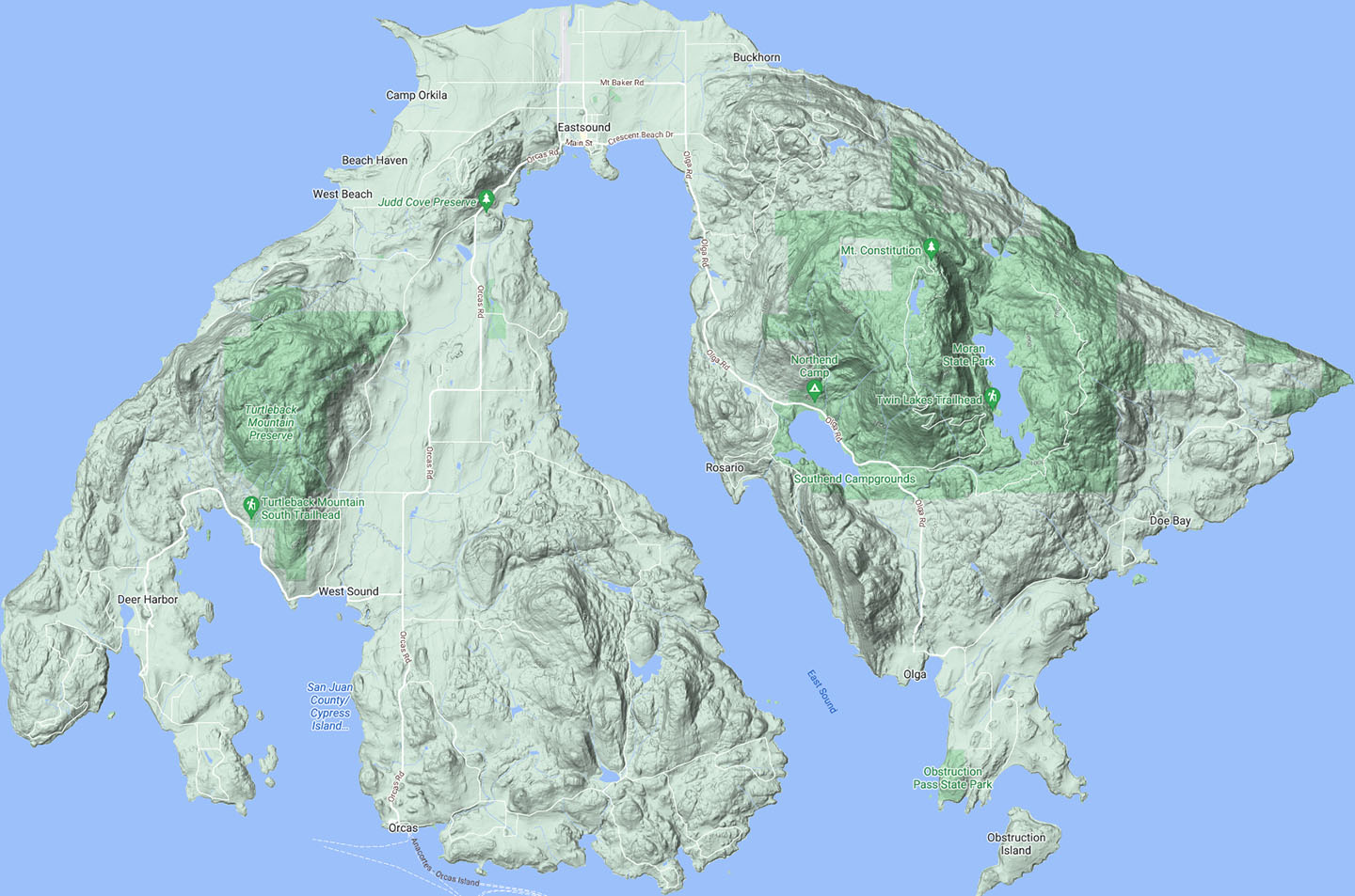
Moran State Park and Mount Constitution
Moran State Park (9). The paved road to the top is indicated. There are also several off-road trails available to cyclist throughout the year.
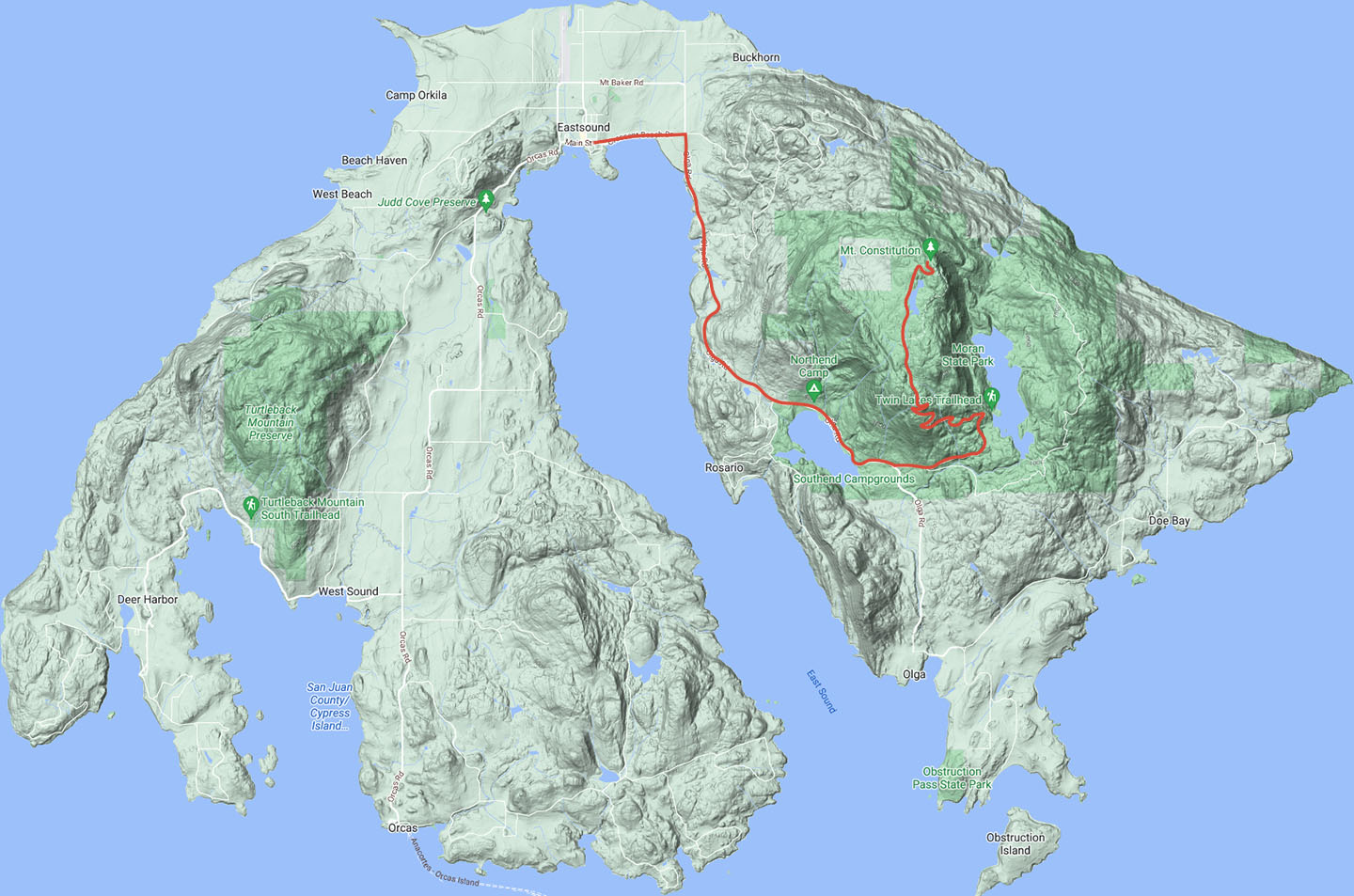
For most cyclists who visit Orcas, the ultimate ride is the trip up Mount Constitution. The summit tower, made of hand-worked stone, affords what some believe is the best marine view in the world… a 360-degree outlook on the island-studded seas between Vancouver Island and the mainland of Washington State.
From Eastsound, follow Horseshoe Highway east and then due south to the park gate, about a five-mile ride up and down medium slopes. The biggest rise is Flaugherties Hill, 3.5 miles from town.
Once you pass under the concrete arch at the entrance to Moran State park, you’ll face a five-mile uphill ride. A small, paved road switchbacks through the ridge face, at times steepening to a 15 percent grade. Most of the climbing will be behind you once you hit Little Summit, where the road flattens for about half a mile through alpine marshes. After a few more switchbacks, you’ll arrive in the parking lot where a 100-foot trail leads to the impressive stone tower at the top of Mount Constitution.
Because the Mount Constitution ride will take you up some steep inclines, you’ll want your brakes in good working order for the descent. Also, bring plenty of water.
There are several worthwhile mountain biking routes open to cyclists in the park.
From September 15 to May 15 a number of walking trails become available for mountain biking. A map with descriptions of the trails is available at the park and at WildLife Cycles.
9
Eastsound
Moran State Park Map (.pdf)

Riding East –
Rosario, Olga, Obstruction Pass, and Doe Bay
Along with Moran State Park and Mount Constitution, a number of routes on the eastern lobe of Orcas are available to cyclists. Just before Horseshoe Highway reaches the park, a clearly marked right turn will lead you to Rosario Resort (10). The resort is a popular place to stay, and it offers several restaurants where you can stop for lunch. Don’t eat too much though, because you’ll pay for the lazy trip down with a steep ride back up to the main road. The resort also has historical value as the former home of the tycoon who provided the land for Moran State Park, and a portion of his mansion is now a museum open to the public.
For leisurely enjoyment of the Orcas scene, a nice option is to continue south on Horseshoe Highway past the turnoff to Mount Constitution. You’ll soon reach a one-lane bridge, and once you cross it you’ve left the park. From there, a couple of rollers with a steep downhill run at the end bring you to an intersection about 2.5 miles from the park boundary. Most traffic turns left here, but you can continue on a few hundred yards to Olga (13), a waterfront community with a store and post office.
The left turn takes you on to Doe Bay Road and through one of the more serene sections of the island. You’ll notice less traffic, and after a pleasant 4-mile ride with several conspicuous hills you’ll get to Doe Bay Resort. There, if you are inclined, you can disrobe or put on a swimsuit and check out the assortment of hot and cold tubs as well as the resort’s sauna. Alternatively, you can ride north from Doe Bay and explore one of the least-travelled public roadways on Orcas. You’ll have to come back the same way, though, because the road is a dead end.
A nice view to the south can be had by turning right off of Doe Bay Road and heading toward Obstruction Pass (11). After about a mile of hilly paved road you come to a point where you can turn right and head down to the marine park parking lot, or you can stay to the left on Obstruction Pass Road and end up at the public dock. We suggest the marine park as a nice place to have a picnic and poke around on some of the island’s most attractive public beachfront.
11
10
13
12
Eastsound
Riding West – Deer Harbor
We’ve already discussed the roadways that lead to and from West Sound: see Routes from the Orcas ferry landing to Eastsound. From West Sound, if you continue on Deer Harbor Road (5), you can enjoy one of the most scenic rides on Orcas. After tracing the waterfront for about a mile, the road climbs slightly inland along a fairly steep grade until you get to a sharp curve, where you veer to the south. The final stretch takes you through an open area with a rolling field on your left. At Deer Harbor Resort (6), about six miles from West Sound, the public roadway ends with a nice view out toward the Wasp Islands, a subset of the San Juans. The resort itself features a post office, restaurant, gift shop, and convenience store, all perched above a busy marina favored by the big-boat crowd. Last year, Deer Harbor Resort built a fancy new dock with pay showers in the dockhouse.
1
2
5
6
4
8


Orcas Island has the highest mountain peaks in the county. Narrow, winding roads connect its hamlets and villages
Or click pins to view route details.
Select route:
West – Deer Harbor
East – Rosario, Olga, Obstruction Pass, and Doe Bay
Moran State Park and Mount Constitution
Orcas ferry landing to Eastsound
Most cyclists arrive on Orcas at the ferry landing (number 1 on the map below), so their introduction to the island roads begins at the western tip of Horseshoe Highway (2), so named because of the arched route it follows from the ferry landing to Olga (13), some 15 miles away.
The arrival of the ferry on Orcas means one important thing to cyclists: traffic. A large ferry might disgorge 100 or more cars, and most of them end up on the Horseshoe Highway route into Eastsound (8). It’s a good idea to save your lungs and your sanity by waiting until the crowd has dispersed.
Although Horseshoe Highway is the shortest and flattest route into town, the volume and speed of the traffic can be intimidating. You can largely avoid this problem, and choose a more scenic route in the bargain, by taking Crow Valley Road (4). To get there, follow Horseshoe Highway 1.5 miles to the West Sound turn, where you take a left. A half-mile downhill run takes you to West Sound, where you’ll reach an intersection with a nice view of a harbor on your left. Take a right onto Crow Valley Road and follow it for 4.75 miles. You’ll come to a stop sign with a hardware store on your left.
At this point, you can go straight ahead and rejoin Horseshoe Highway for a mostly downhill run to Eastsound, or you can turn left and take Enchanted Forest Road (7) all the way to town. This route adds about two miles and some challenging hills to the ride, but the scenery is great. By following signs, you can also take a short detour to West Beach Resort and get a view out into President Channel. A small store at the resort sells soft drinks, beer and basic grocery items.
The overall mileages to Eastsound are as follows: Horseshoe Highway, 7 miles; Crow Valley Road/Horseshoe Highway, 8 miles; Crow Valley Road/Enchanted Forest Road, 10 miles.
Cyclists who are itching for a vigorous ride after being cooped up in a car and on the ferry should consider the White Beach/Dolphin Bay route (3). This long, hilly (a good portion gravel) bypass is the least-traveled public road on Orcas. We recommend a mountain bike for the ride, but you can make it on skinny tires if you’re careful. At the end of the ferry ramp, take a right (most of the other traffic will go left). Follow White Beach Road to Killebrew Lake, a 13-acre body of water covered with lily pads and nestled against fir-covered hills — worth a picture or two at least, and a longer pause if you’re a birdwatcher. At the lake, you’ll reach a Y-shaped intersection where you veer left onto Dolphin Bay Road and the pavement ends. After a couple miles of gravel and hills, you’ll hit pavement again, and a couple miles down the road you’ll reach a three-way stop. Turn right, and you’ll arrive at Horseshoe Highway after a quarter mile. On this route, the total distance to Eastsound is 12 miles.
1
2
3
4
7
8
Moran State Park (9). The paved road to the top is indicated. There are also several off-road trails available to cyclist throughout the year.
For most cyclists who visit Orcas, the ultimate ride is the trip up Mount Constitution. The summit tower, made of hand-worked stone, affords what some believe is the best marine view in the world… a 360-degree outlook on the island-studded seas between Vancouver Island and the mainland of Washington State.
From Eastsound, follow Horseshoe Highway east and then due south to the park gate, about a five-mile ride up and down medium slopes. The biggest rise is Flaugherties Hill, 3.5 miles from town.
Once you pass under the concrete arch at the entrance to Moran State park, you’ll face a five-mile uphill ride. A small, paved road switchbacks through the ridge face, at times steepening to a 15 percent grade. Most of the climbing will be behind you once you hit Little Summit, where the road flattens for about half a mile through alpine marshes. After a few more switchbacks, you’ll arrive in the parking lot where a 100-foot trail leads to the impressive stone tower at the top of Mount Constitution.
Because the Mount Constitution ride will take you up some steep inclines, you’ll want your brakes in good working order for the descent. Also, bring plenty of water.
There are several worthwhile mountain biking routes open to cyclists in the park.
From September 15 to May 15 a number of walking trails become available for mountain biking. A map with descriptions of the trails is available at the park and at WildLife Cycles.
9
Eastsound
Along with Moran State Park and Mount Constitution, a number of routes on the eastern lobe of Orcas are available to cyclists. Just before Horseshoe Highway reaches the park, a clearly marked right turn will lead you to Rosario Resort (10). The resort is a popular place to stay, and it offers several restaurants where you can stop for lunch. Don’t eat too much though, because you’ll pay for the lazy trip down with a steep ride back up to the main road. The resort also has historical value as the former home of the tycoon who provided the land for Moran State Park, and a portion of his mansion is now a museum open to the public.
For leisurely enjoyment of the Orcas scene, a nice option is to continue south on Horseshoe Highway past the turnoff to Mount Constitution. You’ll soon reach a one-lane bridge, and once you cross it you’ve left the park. From there, a couple of rollers with a steep downhill run at the end bring you to an intersection about 2.5 miles from the park boundary. Most traffic turns left here, but you can continue on a few hundred yards to Olga (13), a waterfront community with a store and post office.
The left turn takes you on to Doe Bay Road and through one of the more serene sections of the island. You’ll notice less traffic, and after a pleasant 4-mile ride with several conspicuous hills you’ll get to Doe Bay Resort. There, if you are inclined, you can disrobe or put on a swimsuit and check out the assortment of hot and cold tubs as well as the resort’s sauna. Alternatively, you can ride north from Doe Bay and explore one of the least-travelled public roadways on Orcas. You’ll have to come back the same way, though, because the road is a dead end.
A nice view to the south can be had by turning right off of Doe Bay Road and heading toward Obstruction Pass (11). After about a mile of hilly paved road you come to a point where you can turn right and head down to the marine park parking lot, or you can stay to the left on Obstruction Pass Road and end up at the public dock. We suggest the marine park as a nice place to have a picnic and poke around on some of the island’s most attractive public beachfront.
11
10
13
12
Eastsound
We’ve already discussed the roadways that lead to and from West Sound: see Routes from the Orcas ferry landing to Eastsound. From West Sound, if you continue on Deer Harbor Road (5), you can enjoy one of the most scenic rides on Orcas. After tracing the waterfront for about a mile, the road climbs slightly inland along a fairly steep grade until you get to a sharp curve, where you veer to the south. The final stretch takes you through an open area with a rolling field on your left. At Deer Harbor Resort (6), about six miles from West Sound, the public roadway ends with a nice view out toward the Wasp Islands, a subset of the San Juans. The resort itself features a post office, restaurant, gift shop, and convenience store, all perched above a busy marina favored by the big-boat crowd. Last year, Deer Harbor Resort built a fancy new dock with pay showers in the dockhouse.
1
2
5
6
4
8